Etowah County Supporting Data for Entry of Consent Decree
Public Court Documents
September 23, 1986
27 pages
Cite this item
-
Case Files, Dillard v. Crenshaw County Hardbacks. Etowah County Supporting Data for Entry of Consent Decree, 1986. e85fa7a6-b7d8-ef11-a730-7c1e527e6da9. LDF Archives, Thurgood Marshall Institute. https://ldfrecollection.org/archives/archives-search/archives-item/c807a996-6c83-4deb-8b0a-b07523586129/etowah-county-supporting-data-for-entry-of-consent-decree. Accessed August 03, 2026.
Copied!
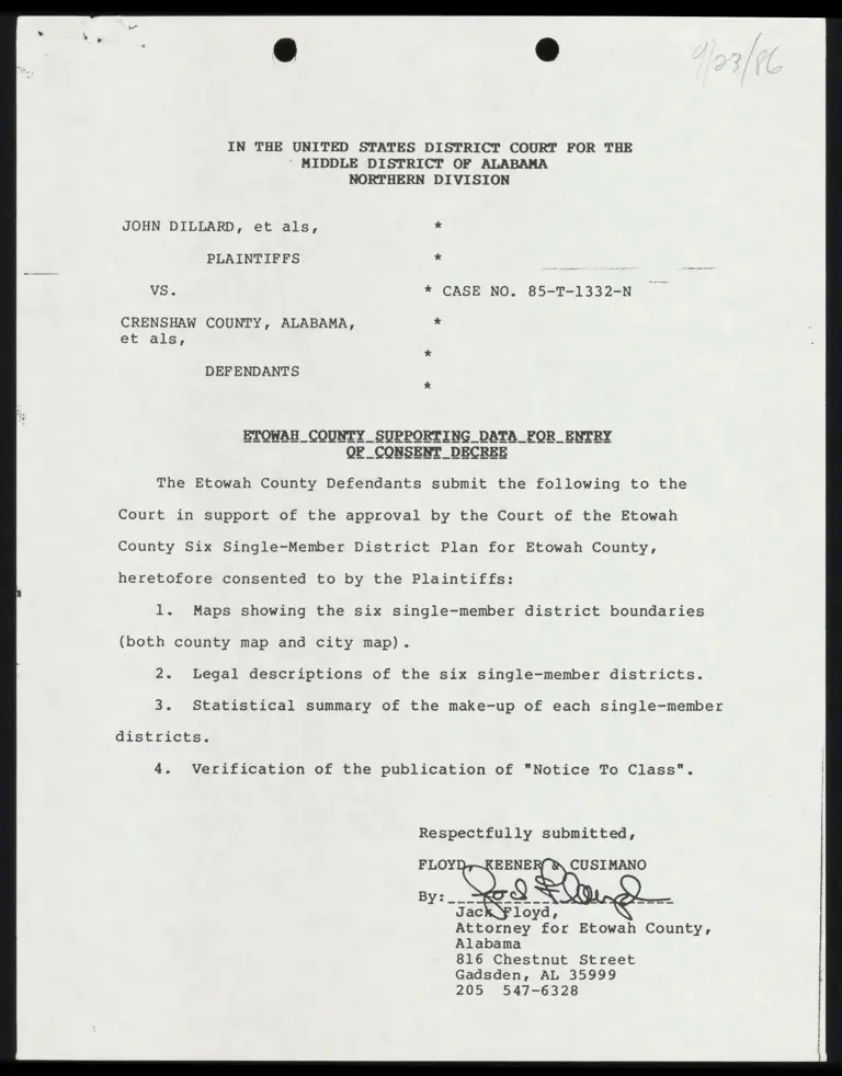
    IN THE UNITED STATES DISTRICT COURT FOR THE
* MIDDLE DISTRICT OF ALABAMA

NORTHERN DIVISION

JOHN DILLARD, et als, *

PLAINTIFFS * 5

VS. * CASE NO. 85-T-1332-N

CRENSHAW COUNTY, ALABAMA, *
et als,

*

DEFENDANTS

ETOWAH COUNTY SUPPORTING DATA _FOR_ENTRY

The Etowah County Defendants submit the following to the

Court in support of the approval by the Court of the Etowah

County Six Single-Member District Plan for Etowah County,

heretofore consented to by the Plaintiffs:

l. Maps showing the six single-member district boundaries

(both county map and city map).

2. Legal descriptions of the six single-member districts.

3. Statistical summary of the make-up of each single-member

districts.

4. Verification of the publication of "Notice To Class".

Respectfully submitted,

FLOY EENE CUSIMANO

Attorney for Etowah County,
Alabama
816 Chestnut Street
Gadsden, AL 35999
205 547-6328


I hereby certify that a copy of the foregoing has been

mailed James Blacksher, Attorney, P. O. Box 1051, Mobile, AL

36633; Larry T. Menefee, Attorney, 300 21st Avenue, North, Title

Building, 5th Floor, Birmingham, Alabama 35203; Terry G. Davis,

P. O. Box 6215, Montgomery, Alabama 36104; Deborah Fins, Julius

L. Chambers, 99 Hudson Street, 16th Floor, New York, New York

10013; Edward Still, 714 South 29th Street, Birmingham, AL

35233; and Reo Kirkland, Jr., P. O. Box 646, Brewton, AL 36427,

Alton Turner, Crenshaw County Attorney, P. O. Box 207, Luverne,

AL 36049, Dave Martin, Lawrence County Attorney, 215 S. Main

Street, Moulton, AL 35650, Warner Rowe, Coffee County Attorney,

119 East College Avenue, Enterprise, AL 36330, H. R. Burnham,

Calhoun County Attorney, P. O. Box 1618, Anniston, AL 36202,

Barry D. Vaughn, Talladega County Attorney, 121 N. Norton

Avenue, Sylacauga, AL 35150, Lee Otts, Escambia County Attorney,

P. O. Box 467, Brewton, AL 36427, Buddy Kirk, Pickens County

Attorney, P. O. Drawer AB, Carrollton, AL 35447, David R. Boyd,

P. O. Box 78, Montgomery, AL 36104, this the + _day of October,

1986.


A
i


DISTRICT ONE


That part of Etowah County, Alabama described as follows:

All that part of Etowah County lying east of the center of the Coosa River less
and except the following: Begin at a point in the S 1/2 of Section 5, Township
12 South, Range 7 East where the center of the Coosa River intersects the center
of Big Cove Creek if projected in a northerly direction; thence run in a southerly

direction along the said projection of and along the center of Big Cove Creek to
the intersection with Little Cove Creek; thence run in a southeasterly direction
along the center of Little Cove Creek to the intersection with U.S. Highway 278;
thence run in a westerly direction along the center of U.S. Highway 278 to the
intersection with Kaying Road; thence run in a southerly and southeasterly direction
along the center of Kaying Road to the intersection with a northerly projection of
the East line of Iot 1, Block 5S of Meadow Grove Acres as recorded in Plat Book “",
Pages 41 and 43 in the Judge of Probate Office, Etowah County, Alabama; thence run
in a southerly direction and along the said northerly projection of the East line
and along the East line of said Lot 1, Block 5 to the Northwest corner of Lot 40,
Block 5S of Meadow Grove Acres; thence run in a northeasterly direction along the
North line of said Lot 40, Block 5 to the Northeast corner thereof; thence run in
a southeasterly direction along the easternmost line of said Lot 40, Block 5 to the
easternmost corner thereof; said corner being located on the West right-of-way of
Pennalg Boulevard: thence rug in a_southerly direction along the west right-of-way of
Pennala Boulevard to_the intersection with the North right-of-way OF Pennala Cross
way; thence run in a westerly direction along the North right-of-way of Pefinala Cross-
way to the intersection with the East right-of-way of Allen Boulevard; thence run in
a southerly direction and along the East right-of-way of Allen Boulevard to the North- .
west corner of Lot 51, Block 6 of said Meadow Grove Acres; thence run in an easterly
direction along the North line of said Lot 51, Block 6 and along the North line of
Lot 46, Block 6 to the Northeast corner of lot 46, Block 6; said corner being located
on the West right-of-way of Pennala Boulevard; thence run in a southerly direction
along the West right-of-way of Pennala Boulevard to the intersection with the North
right-of-way of Paradice Avenue; thence run in a westerly direction along the North
right-of-way of Paradice Avenue to the intersection with the East right-of-way of
Allen Boulevard; thence run in a southerly direction along the East right-of-way and
a projection of the East right-of-way of Allen Boulevard to the intersection with
Burnsway Drive; thence run in a southeasterly direction along the center of Burns-
way Drive to the intersection with Lonesome Bend Road; thence run in a southerly
direction along the center of Lonesame Bend Road to a point 75 feet south of a point
where the centerline of Baldwin Street intersects the centerline of said Lonesome
Bend Road; thence run in a westerly direction along a line 75 feet south of and
parallel to the centerline of Baldwin Street to a point which is 60 feet east of
the centerline of a L & N Railroad Spur Track measured at right-angles; thence run
in a southwesterly direction 60 feet east of and parallel to the centerline of said
L & N Railroad Spur Track to a point 30 feet east of the centerline of Rains Avenue;
thence run in a southerly direction along a line 30 feet east of and parallel to the
Centerline of Rains Avenue-to the intersection with West Air Depot Road; thence run
in a westerly direction along the center of West Air Depot Road to the intersection


“with the Tis N Railroad; thence run in a northwesterly directisn Wlong -the-tenter of     the L & N Railroad to the intersection with Burns Park Road; thence Yum irra westeriy—-- |
and southwesterly direction along the center of Burns Park Road to the intersection :
with Meighan Boulevard or U.S. Highway 431; thence run in a southeasterly direction
along the center of Meighan Boulevard or U.S. Highway 431 to the intersection with
the East line of Section 24, Township 12 South, Range 6 East; thence run in a southerly
direction along the East line of Section 24, Township 12 South, Range 6 East to the


DISTRICT TWO


That part of Etowah County, Alabama described as follows:

foot of Lookout Mountain to a point where the same intersects the Southeast right- of-way of Interstate Highway No. 59 in Section 34, Township 10 South, Range 6 East: thence continue in a southwesterly direction along the Southeast right-of-way of Interstate Highway No. 59 and also along the Northwest foot of Lookout Mountain to the intersection with Noccalula Road or Alabama Highway No. 211; thence run in a southerly direction along the center of Noccalula Road or Alabama Highway No. 211 to the intersection with Scenic Drive; thence run in a southwesterly direction along the center of Scenic Drive to the intersection with Skyway Street; thence run in a southeasterly and southerly direction along the center of Skyway Street to the inter— section with Sunset Drive; thence run in a northeasterly direction along the center of Sunset Drive to the intersection with Lookout Street; thence run in a southeasterly direction along the center of Lookout Street to the intersection with Hinds Road: thence run in a westerly, southwesterly, and southeasterly direction along the center of Hinds Road to the intersection with an unnamed stream located in the North 1/2 of the North 1/2 of Section 31, Township 11 South, Range 6 East; thence run in a south- easterly direction along the center of said unnamed stream to the intersection with Black Creek; thence run in a southerly direction along the center of Black Creek to the intersection with Tuscaloosa Avenue; thence run in a southeasterly direction along the center of Tuscaloosa Avenue to the intersection with Noccalula Road or Alabama Highway 211; thence run in a northwesterly direction along the center of Noccalula Road or Alabama Highway No. 211 to the intersection with -Harts Avenue; thence run in a southeasterly direction along the center of Harts Avenue to the intersection with Bellevue Drive; thence run in a southerly, easterly and northeasterly direction along the center of Bellevue Drive to the intersection with Highland Avenue; thence

center of the Alabama Power Company Trans- mission Line right-of-way to the intersection with McCoy Street; thence run in a southwesterly direction along the center of McCoy Street and Valley Street to the intersection with Grant Street; thence run in a southeasterly direction and then a southwesterly direction along the center of Grant Street to the intersection with
Elmore Street; thence run in a southwesterly direction along the center of Elmore Street to the intersection with Reservoir Street; thence run in a southwesterly direction along the center of Reservoir Street to the intersectiori-with Ewing Avenue; thence run in an easterly direction along the center of Ewing Avenue to the inter—


section with River Street; thence run in a southeasterly direction along the center of River Street to the intersection with Albert Rains Boulevard; thence run in a
southwesterly direction along the center of Albert Rains Boulevard to the inter- section with Meighan Boulevard; thence run in a southeasterly direction along the


-2-

center of Meighan Boulevard to the intersection with the center of the Coosa
River; thence run in a northeasterly and southeasterly direction along the center
of the Coosa River to the intersection with the L & N Railroad (Goodyear and Alabama
Power Company Spur) if projected in an easterly direction; thence run in a westerly,
southwesterly, westerly and southerly direction along the said projection thereof and
along the center of the L & N Railroad (Goodyear and Alabama Power Campany Spur) to i
the intersection with Meighan Boulevard; thence run in a northwesterly direction
along the center of Meighan Boulevard to the intersection with North 6th Street;
thence run in a southwesterly direction along the center of North 6th Street to the
intersection with Nuckolls Street; thence run in a southeasterly direction along the
center of Nuckolls Street to the intersection with Hoke Street; thence run in an
easterly direction along the center of Hoke Street to the intersection with Slusser
Avenue; thence run in a southerly direction along the center of Slusser Avenue to the
intersection with Grant Avenue; thence run in a southeasterly direction along the center
of Grant Avenue to the intersection with Richardson Street; thence run in an easterly
direction along the center of Richardson Street to the intersection with Litchfield
Avenue; thence run in a southeasterly direction along the center of Litchfield Avenue
to the intersection with Springfield Avenue; thence run in an easterly direction along
the center of Springfield Avenue to the intersection with Meighan Boulevard; thence
run in a northwesterly direction along the center of Meighan Boulevard to the inter-
section with U.S. Highway No. 278; thence run in an easterly direction along the
center of U.S. Highway No. 278 to the intersection with Little Cove Creek; thence -

T Trumrin a northwesterly -direction-along—the-center-of-Little Cove Creek to the -inter—- —. .
section with Big Cove Creek; thence run in a northerly direction along the center of
Big Cove Creek and along a projection thereof to the intersection with the center of
the Coosa River; thence run in a northeasterly direction along the center of and along
‘the meanderings of the center of the Coosa River to the intersection with the Etowah-
Cherokee County, Alabama line; thence run in a northerly direction along the said
Etowah-Cherokee County Line to the intersection with the Etowah-DeKalb County, Alabama
line; thence run in a westerly direction along said Etowah-DeKalb County line to the
intersection with the Northwest foot of Lookout Mountain in Section 4, Township 10
South, Range 7 East and the point of beginning.


DISTRICT THREE:

That part of Etowah County, Alabama described as follows:

Begin on the Etowah-Marshall County Line at a point where the centerline of Ala- bama Highway 179 intersects said county line in Section 11, Township 10 South, Range 4 East; thence run ina southerly direction along the center of Alabama Highway 179 to the intersection with U.S. Highway 278; thence run in an easterly direction along the center of U.S. Highway 278 to the intersection with Alabama Highway 77; thence run in a northeasterly direction along the center of Alabama Highway 77 to the intersection with U.S. Highway 431; thence run in a southerly direction along the center of U.S. Highway 431 to the intersection with Big Wills Creek; thence run in a southwesterly direction along the center of Big Wills Creek to the intersection with Clear Creek; thence run in a westerly direction along the center of Clear Creek to the intersection withAlabama Highway 77; thence run in a southerly direction along the center of Alabama Highway 77 to the intersection with Clanton Street S. W. (which is also called Gaines Chapel Road); thence run in a southwesterly direction along the center of Clanton Street S. W. or Gaines Chapel Road to the intersection with Gaines Street S. W.; thence run in a southeasterly direction along the center of Gaines Street S. W. to the intersection with U.S. Highway 11; thence run in a northeasterly direction along the center of U.S. High- way ll to the intersection with Altoona Avenue S.W.; thence run in a southeasterly direction along the center of.Altoona Avenue S.W. to the intersection with Alabama Street S.W.; thence run in a northeasterly direction along the center of Alabama Street S.W. to the intersection with Alabama Highway 77; thence run in a south- easterly direction along the center of Alabama Highway 77 to the intersection with the Southern Railroad; thence run in a northeasterly direction along the center of said Southern Railroad to the intersection with 3rd Avenue N.E. in the City of Attalla, Alabama; thence run-in a southeasterly direction along the center of 3rd Avenue N.E. to the intersection with 2nd Street N.E.; thence run in a northeasterly direction along the center of 2nd Street N.E. to the intersection with 4th Avenue N.E.; thence run in a southeasterly direction along the center of 4th Avenue N.E. to the inter- section with lst Street N.E. ; thence run in a northeasterly direction along the center of lst Street N.E. to the intersection with 6th Avenue N.E.; thence run in a northwesterly direction along the center of 6th Avenue N.E. and 6th Avenue N.W. to the intersection with 4th Street N.W. ; thence run in a northeasterly direction along the center of 4th Street N.W. to the intersection with Sth Street N.W.; thence run in a westerly and southwesterly direction along the center of 5th Street N.W. to the intersection with 8th Avenue N.W. ; thence run in a northwesterly direction along the center of 8th Averme N.W. and along a projection thereof to the inter section with Old Boaz Road or Wesson Gap Road; thence run in a northeasterly, west- erly and northerly direction along the center of Old Boaz Road or Wesson Gap Road to the intersection with the Crest of Big Ridge; thence run in a northeasterly direction along the Crest of Big Ridge to the intersection with an unnamed creek in the NE 1/4 of Section 2€, Township 11 South, Range 5 East; thence run in a southeasterly dir- ection along the center of said unnamed creek to the intersection with Little Wills Creek in the SW 1/4 of Section 25, Township 11 South, Range S East; thence run in a southwesterly direction and along the center of Little Wills Creek to the inter- ; section with the North line of Section 2, Township 12 South, Range 5 East, which is


-2-

also the Gadsden-Attalla Corporate Limits line; thence run in an easterly direction
along the North line of said Section 2 and along the Gadsden-attalla Corporate Limits
line to the Northeast corner of said Section 2; thence run in a southwesterly dir-
ection along the East line of said Section 2, Township 12 South, Range 5 East, which
is also the Gadsden-Attalla'Corporate Limits line to the intersection with Meighan
Boulevard; thence run in an easterly direction along the center of Meighan Boulevard
to the intersection with North 13th Street; thence run in a northeasterly direction
along the-eenter of North 13th-Street to the intersection with Kyle Avenue; thence
run in a westerly direction along the center of Kyle Avenue to the intersection with
North 13th Street; thence run in a northerly direction along the center of North 13th
Street to the intersection with Tuscaloosa Avenue; thence run in a northwesterly dir-
ection along the center of Tuscaloosa Avenue to the intersection with Black Creek;
thence run in a northerly direction along the center of Black Creek to the inter-
section with an unnamed stream located in the North 1/2 of the North 1/2 of Section
31, Township 11 South, Range 6 East; thence run in a northwesterly direction along
the center of said unnamed stream to the intersection with Hinds Road; thence run in
a northwesterly, northeasterly and easterly direction along the center of Hinds Road
to the intersection with Lookout Street; thence run in a northwesterly direction
along the center of Lookout Street to the intersection with Sunset Drive; thence
run in a southwesterly direction along the center of Sunset DRive to the intersection
with Skyway Street; thence run in a northerly and northwesterly direction along the .
center of Skyway Street to the intersection with Scenic Drive; thence run in a north-
easterly direction along the center of Scenic Drive to the intersection with Noccalula
Road or Alabama Highway-No. 211; thence run in a northerly direction along the ‘center
of Noccalula Road or Alabama Higtway No. 211 to the intersection with the Southeast
right-of-way of Interstate Highway No. 59 and also being the Northwest foot of Look-
out Mountain; thence run in a northeasterly direction along the Southeast right-of-
way of Interstate Highway No. 59 and also along the Northwest foot of Lookout Mountain
to a point where said Southeast right-of-way of Interstate Highway No. 59 turns in a
northerly direction and leaves the Northwest foot of Lookout Mountain in Section 34,
Township 10 South, Range 6 East; thence continue to run in a northeasterly direction
along the Northwest foot of Lookout Mountain to the intersection with the Etowah-
DeKalb County line in Section 4, Township 10 South, Range 7 East; thence run in a
westerly direction along the Etowah-DeKalb County line to the intersection with the
Etowah-Marshall County line; thence run in a southerly and then westerly direction
along the Etowah-Marshall County line to the intersection with the centerline of
Alabama Highway No. 179 in Section 11, Township 10 South, Range 4 East and the point
of beginning.


DISTRICT FOUR
That part of Etowah County, Alabama, described as follows:

Begin on the Etowah-Marshall County line at a point where the centerline of Alabama Highway 179 intersects said County line in Section 11, Township 10 South, Range 4 East; thence run in a southerly direction along the center of Alabama Highway 179 to the intersection with U.S. Highway 278; thence run 1n an easterly direction along the center of U. S. Highway 278 to the intersection with Alabama Highway 77; thence run in a northeasterly direction along the center of Alabana Highway 77 to the intersection with U.S. Highway 431; thence run in a southerly direction along the center of U.S. Highway 431 to the intersection with Big Wills Creek; thence run in a southwesterly direction along the center of Big Wills Creek to the intersection with Clear Creek; thence run in a westerly direction along the center of Clear Creek to the intersection with Alabama Highway 77; thence run in a southerly direction along the center of Alabama Highway 77 to the intersection with Clanton Street S. W. (which is also called Gaines Chapel Road): thence run in a southwesterly direction along the center of Clanton Street S.W. or Gaines Chapel Road to the intersection with Gaines Street S.W.; thence run in a southeasterly direction along the center of Gaines Street S.W. to the intersection with U.S. Highway 11; thence run in a northeasterly direction along the center of U.S. Highway 11 to the intersection with Altoona Avenue S.W.; thence run in a southeasterly direction along the center of Altoona Avenue S.W. to the intersection with Alabama Street S.W.; thence run in a northeasterly direction along the center of Alabama Street S.W. to the intersection with Alabama Highway 77; thence Tun in

of the Southern Railroad to the intersection with Big Wills Creek; thence run in a

Interstate Highway Nc. 59; thence run in a northerly direction along the center of

the intersection with Wilson Street; thence run in a southerly direction along the center of Wilson Street to the intersection with Walnut Street; thence run in an easterly direction along the center of Walnut Street to the intersection with Brooke Avenue; thence run in a southwesterly direction along the center of Brooke Avenue to the intersection with Big Wills Creek; thence run in a southeasterly direction along the center of Big Wills Creek to the intersection with the East line of Section 20, Township 12 South, Range 6 East; thence run in a southerly direction along the East line of said Section 20, Township 12 South, Range 6 East to the North- east corner of the SE1l/4 of said Section 20; thence run in a westerly direction and along the North line of the SE 1/4 of said Section 20 to the Northwest corner thereof; thence run in a southerly direction and along the West line of the NW 1/4 of the SE 1/4 of said Section 20 to the Southwest corner thereof; which said point is also the Northwest corner of the SW 1/4 of the SE 1/4 of said Section 20; thence run in an easterly direction and along the South line of the NW 1/4 of the SE 1/4 which line is also the North line of the SW 1/4 of the SE 1/4 to a point which is 340 feet West of the West line of the SE 1/4 of the SE 1/4 in said Section 20; thence run in a southerly direction and along a line which is 340 feet West of and parallel to the West line of the SE 1/4 of the SE 1/4 of said Section 20 to a point which is 225 feet North of the South line of said Section 20; thence run in an easterly direction along a line which is 225 feet North of and parallel to the South line of said Section 20 to a point in the East line of said Section 20, which point is also in the West line of Section 21, Township 12 South, Range 6 East; thence run in a southerly direction along the West line of said Section 21, Township 12 South, Range 6 East to the Southwest comer thereof; thence run in an easterly


-2-

direction along the South line of sajd Scctiwon 21 to the intersection with the Southeast right of way of Rainbow Drive or U.S. Highway 411; thence run in a southwesterly direction along the Southcast right of way of Rainbow Drive or U.S. Highway 411 to the intersection with the West. right of way of Kaylu Drive; thence run in a southeasterly and then southwesterly direction along the West right of way of Kaylu Drive to the intersection with the South line of the NW 1/4 of the NW 1/4 in Section 28, Township 12 South, Range 6 Fast; thence run in a westerly direction along the South line of the NW 1/4 of the NW 1/4 of said Section 28 to the Southwest corner thereof, which said point is also in the East line of Section 29, Township 12 South, Range 6 East; thence run in a southerly direction and along the East line of Section 29, Township 12 South, Range 6 East to the Southeast corner of the NE 1/4 of the SE 1/4 of said Section 29; thence run in a westerly direction along the South line of the NE 1/4 of the SE 1/4 of said Section 29 to the intersection with the Northeast right of way of Woodmar Drive; thence run in a northwesterly direction along the Northeast right of way of Woodmar
Drive to the intersection with the northermost line, if projected in a north- easterly direction, of Wildwood Hills as recorded in Plat Book "G", Page 87, in the Judge of Probate Office, Etowah County , Alabama; thence run in a southwesterly direction along said projection of and along said northernmost line of said Wild- wood Hills to the Northwest corner of Lot 9, Blk 6, in Wildwood Hills, said corner being on the West line of the NE 1/4 of the SE 1/4 of said Section 29, Township 12 South, Range 6 East; thence run in a northerly direction along the West line of the NE 1/4 of the SE 1/4 of said Section 29 and said line also being the East line of Bo Wildwood Estates as recorded in Plat Book "G", Page 165 in the Judge of Probate Office, Etowah County, Alabama to the point of intersection with the Northeast line of Lot 18 in said Wildwood Estates; thence run in a northwesterly direction along the Northeast lines of Lots 18, 17, and 16 of said Wildwood Estates to the Northwest corner of said Lot 16; thence run in a southwesterly direction along the Northwest line of Lot 15 in said Wildwood Estates *o the Northwest corner of Lot 14 in said Wildwood Estates; thence run in a southerly direction along the West line of said Lot 14 to the point of intersection with the North line of an area designated “Reserved” in said Wildwood Estates; thence deflect an angle of 90 degrees to the right and run in a westerly direction along the North line of the area designated "Reserved" in said Wildwood Estates a distance of 400 feet to a point; thence deflect an angle of 27 degrees 02 minutes to the right and run in a northwesterly direction a distance of 187.06 feet to a point; thence deflect an angle of 27 degrees 02 minutes to the left and run in a westerly direction a distance of 160 feet to a point in the East right of way of Silvey Street; thence run in a northerly direction along the said East right of way of Silvey Street and along a projection thereof to the intersection with the center of Rainbow Drive or U.S. Highway 411; thence run in a southwesterly direction along the center of Rainbow Drive or U.S. Highway 411 to the intersection with Church Street; thence run in a southerly direction along the center of Church Street to the intersection with Alabama Highway 77;

thence run in a southeasterly direction along the center of Alabama Highway 77 to the intersection with the center of the Coosa River; thence run in a southwesterly, southeasterly and southwesterly direction along the center of and along the meanderings of the center of the Coosa River to the intersection with the Etowah-St.Clair County Line; thence run in a northwesterly , westerly, and southwesterly direction along the Etowah-St.Clair County Line to the intersection with the Etowah-Blount County Line; thence run in a westerly, northeasterly, northerly, and northeasterly direction along the Etowah-Blount County Line to the intersection with the Etowah-Marshall County Line; therce run in a northeasterly direction along the Etowah-Marshall County Line
to the intersection with the centerline of Alabama Highway 179 in Scction 11, Town- ship 10 South, Range 4 East and the point of boginning.


DISTRICT FIVE
That part of Etowah County, Alabama described as follows:

Begin at a point in the City of Gadsden, Alabama, where the center of Broad
Street intersects the center of the Coosa River; thence run in a southwesterly ~direction along the center of the Coosa River to the Intersection with the center- line of Walnut Street if projected in a southeasterly direction; thence run in a northwesterly direction along the said projection of and along the centerline of
Walnut Street to the intersection with South 6th Street; thence run in a north-
easterly direction along the center of South 6th Street to the intersection with
Chestnut Street; thence run in a northwesterly direction along the center of
Chestnut Street to the intersection with South 7th Street; thence run in a
northerly direction along the center of South 7th Street to the intersection with
Forrest Avenue; thence run in a northwesterly direction along the center of
Forrest Avenue to the intersection with North 9th Street: thence run in a north-
easterly direction along the center of North 9th Street to the intersection with
First Avenue; thence run in a northwesterly direction along the center of First
Avenue to the intersection with North 12th Street; thence run in a northerly
direction along the center of North 12th Street to the intersection with Malone
Street; thence run in a westerly direction along the center of Malone Street to the
intersection with Franklin Street; thence run in a southwesterly direction along
the center of Franklin Street to the intersection with Alabama Street; thence run
in an easterly direction along the center of Alabama Street to the intersection with
South 14th Street; thence run in an southerly direction along the center of South
14th Street to the intersection with Hill Avenue; thence run in a westerly direction
along the center of Hill Avenue to the intersection with South 15th Street; thence
run in a southerly direction along the center of South 15th Street to the intersection
with Cansler Avenue; thence run in an easterly direction along the center of Cansler
Avenue to the intersection with South 13th Street: thence run in a southwesterly
direction along the center of South 13th Street to the intersection with Chestnut
Street; thence run in an easterly direction along the center of Chestnut Street to
the intersection with South 12th Street; thence run in a southwesterly direction
along the center of South 12th Street to the intersection with Pine Street; thence
run in an easterly direction along the center of Pine Street to the intersection
with South 12th Street; thence run in a southwesterly direction along the center of
South 12th Street to the intersection with Randall Street: thence run in a westerly
direction along the center of Randall Street to the intersection with Black Creek;
thence rur in a northwesterly direction along the center of Black Creek to the
intersection with Forrest Avenue; thence run in a westerly direction along the center
of Forrest Avenue and Cleveland Avenue to the intersection with Interstate Highway
No. 59; thence run in a southerly direction along the center of Interstate Highway
No. 59 to the intersection with Big Wills Creek; thence run in a southwesterly
direction along the center of Big Wills Creek to the intersection with The Southern
Railroad; thence run in a northeasterly direction along the center of said Southern
Railroad to the intersection with 3rd Avenue N.E. in the City of Attalla, Alabama;
thence run in a southeasterly direction along the center of 3rd Avenue N.E. to the
intersection with 2nd Street N.E.; thence run in a northeasterly direction along the
center of 2nd Street N.E. to the intersection with 4th Avenue N.E.: thence run in a southeasterly direction along the center of 4th Avenue N.E. to the intersection with
Ist Street N.E.; thence run in a northeasterly direction along the center of lst
Street N.E. to the intersection with 6th Avenue N.E.; thence run in a northwesterly
direction along the center of 6th Avenue N.E. and 6th Avenue N.W. to the intersection
with 4th Street N.W.; thence run in a northeasterly direction along the center of - J


,

-2-

the center of 8th Avenue N.W. and along a projection thereof to the intersection with Old Boaz Road or Wesson Gap Road; thence run in a northeasterly, westerly, and northerly direction along the center of Old Boaz Road or Wesson Gap Road to the intersection with the Crest of Big Ridge; thence run in a northeasterly direction

1s alsc the Gadsden-Attalla Corporate Limits Line; thence run in an easterly direction along the North line of said Section 2 and along the Gadsden-Attalla Corporate Limits Line to the Northeast corner of said Section 2; thence run in a southwesterly direction alonc the East line of said Section 2, Township 12 South, Range 5 East, which is also the Gadsden-Attalla Corporate Limits Line to the intersection with Meighan Boulevard; thence run in an easterly direction along the center of Meighan Boulevard to the intersection with North 13th Street; thence run in a northeasterly direction along the center of North 13th Street to the intersection with Kyle Avenue; thence run in a westerly direction along the center of Kyle Avenue to the intersection with North _]3th Street; thence run in a northerly direction along the center of North 13th Street to the intersection with Tuscaloosa Avenue; thence run in a southeasterly direction along the center of Tuscaloosa Avénue to the
intersection with Noccalula Road or Alabama Highway No. 211; thence run in a northwest- erly direction along the center of Noccalila Road or Alabama Highway No. 211 to the intersection with Harts Avenue; thence run in a southeasterly direction along the center of Harts Avenue to the intersection with Bellevue Drive; thence run in a southerly, easterly, and northeasterly direction along the center of Bellevue Drive to the intersection with Highland Avenue; thence run in an easterly direction along the center of Highland Avenue to the intersection with the Crest of Lookout Mountain: thence run in a northeasterly direction along the Crest of Lookout Mountain to the intersection with the Alabama Power Company Transmission Line right-of-way in Section 27, Township 11 South, Range 6 East; thence run in a southeasterly direction along the center of the Alabama Power Company Transmission Line right-of-way to the intersection with McCoy Street; thence run in a southwesterly direction along the center of McCoy Street and Valley Street to the intersection with Grant Street; thence run in a Southeasterly direction and then a southwesterly direction along the center of Grant

thence run in a southwesterly direction along the center of Elmore Street to the intersection with Reservoir Street; thence

direction along thz center of River Street to the intersection with Albert Rains
Boulevard; thence run in a southwesterly direction along the center of Albert Rains Boulevard to the intersection with Meighan Boulevard; thence run in a southeasterly direction along the center of Meighan Boulevard to the intersection with-the center of the Goosa River; thence run in a northeasterly and southeasterly direction along the center of the Coosa River to the intersection with the L & N Railroad (Goodyear and Alabama Power Company Spur) if projected in an easterly direction; thence run in a
westerly, southwesterly, westerly, and southerly direction along the said projection thercof and along the center of the L & N Railroad (Goodyear and Alabama Power ! Company Spur) to the intersection with Meighan Boulevard; thence run in a north- westerly direction along the center of Meighan Boulevard to the intersection with


-3-

North 6th Street; thence run in a southwesterly direction along the center of
North 6th Street to the intersection with Nuckolls Street; thence run in a
southeasterly direction along the center of Nuckolls Street to the intersection
with Hoke Street; thence run in an easterly direction along the center of Hoke
Street to the intersection with Slusser Avenue; thence run in a southerly direction
along the center of Slusser Avenue to the intersection with Grant Avenue: thence
run in a southeasterly direction along the center of Grant Avenue to the intersection
with Richardson Street; thence run in an easterly direction along the center of
Richardson Street to the intersection with Litchfield Avenue; thence run in a
southeasterly direction along the center of Litchfield Avenue to the intersection
with Springfield Avenue; thence run in an easterly direction along the center of
Springfield Avenue to the intersection with Meighan Boulevard; “hence run in a
northwesterly direction along the center of Meighan Boulevard to the intersection
with U.S. Highway 278; thence run in an easterly direction along the center of
U.S. Highway 278 to the intersection with Kaying Road; thence run in a southerly
and southeasterly direction along the center of Kaying Road to the intersection with
a northerly projection of the East line of Lot 1, Block 5 of Meadow Grove Acres as
recorded in Plat Book "F", Pages 41 and 43, in the Judge of Probate Office, Etowah
County, Alabama; thence run in a southerly direction and along the said northerly
projection of the East line and along the East line of said Lot 1, Block S to the
Northwest corner of Lot 40, Block 5 of Meadow Grove Acres; thence run in a north-
easterly direction along the North line of said Lot 40, Block 5 to the Northeast -
.corper_thereof; thence run in a southeasterly direction along the easternmost
line of said Lot 40, Block 5 to the easternmost corner thereof; said cornér being
located on the West right-of-way of Pennala Boulevard; thence run in a southerly
direction along the West right-of-way of Pennala Boulevard to the intersection with
the North right -of-way of Pennala Crossway; thence run in a westerly direction along
the North right-of-way of Pennala Crossway to the intersection with the East right-of-
way of Allen Boulevard; thence run in a southerly direction and along the East right-
of-way of Allen Boulevard to the Northwest corner of Lot 51, Block 6 of said
Meadow Grove Acres; thence run in an easterly direction along the North line of
said Lot 51, Block 6 and along the North line of .Lot 46, Block 6 to the Northeast
corner of Lot 46, Block 6; said corner being located on the West right-of-way of
Pennala Boulevard; thence run in a southerly direction along the West right-of-way
of Pennala Boulevard to the intersection with the North right. -of way of Paradice
Avenue; thence run in a westerly direction along the North right-of-way of Paradice
Avenue to the intersection with the East right-of-way of Allen Boulevard; thence run
in a southerly direction along the East right-of-way and a projection of the East
right-of-way of Allen Boulevard to the intersection with Burnsway Drive; thence. run
in a southeasterly direction along the center of Burnsway Drive to the. intersection
with Lonesome Bend Road; thence run in’ a southerly direction along the center of
Lonesome Bend Road toa point75 feet South of a point where the centerline of

Baldwin Street intersects the centerline of said Lonesame Bend Road; thence run in a
westerly direction along a line 75 feet South of and parallel to the centerline of
Baldwin Street to a point which is 60 feet East of the centerline of a L & N Rail-
road Spur Track measured at right angles; thence run in a southwesterly direction
60 feet East of and parallel to the centerline of said L & N Railroad Spur Track
to a point 30 fe=t East of the centerline of Rains Avenue; thence run in a southerly
direction along a line 30 feet East of and parallel to the centerline of Rains
Avenue to the intersection with West Air Depot Road; thence run in a westerly
direction along the center of West Air Depot Road to the intersection with the
L & N Railroad; thence run in a northwesterly direction along the center of the
L & N Railroad to the intersection with Industrial Parkway; thence run in a
southwesterly direction along the center of Industrial Parkway to the intersection
with Meighan Boulevard or U.S. Highway 431; thence run in a northwesterly direction


-4-

along the center of Meighan Boulevard or U.S. Highway 431 to the intersection
with Florida Avenue; thence run in a southwesterly direction along the center
of Florida Avenue to the intersection with Keeling Bend Road; thence run in a
southeasterly direction along the center of Keeling Bend Road to the intersection
with Margaret Street; thence run in an easterly direction along the center of
Margaret Street to the intersection with Nunnally Avenue; thence run in a
sautherly direction along the center of Nunnally Avenue. to the intersection with
Gray Road; thence run in a westerly and southwesterly direction along the center
of Gray Road to the intersection with U.S. Highway 431 and 278 Bypass or College
Parkway; thence run in a westerly direction along the center of U.S. Highway 431
and 278 Bypass or College Parkway to the intersection with the West line of the
SE 1/4 of the NW 1/4 of Section 24, Township 12 South, Range 6 East which line is
also the West right-of-way line of Wilmer Avenue; thence run in a northerly
direction along the West line of said SE 1/4 of the NW 1/4 and along the West
right-of-way line and a projection of the West right-of-way line of Wilmer Avenue
to the intersection with Springrock Street; thence run in a westerly direction along
the center of Springrock Street to the intersection with Paden Road; thence run in
a northwesterly direction along the center of Paden Road to the intersection with
the East line of the NE 1/4 of the NW 1/4 of Section 23, Township 12 South, Range
6 East which line ic also the centerline of Line Street; thence run in a northerly
direction along the East line of said NE 1/4 of the NW 1/4 and along the centerline
of Line Street to the intersection with Coolridge Street; thence run in a westerly
direction-along the-center-of Coolridge. Street to the intersection with Paden Road;
thence run in a northwesterly and northerly direction along the center of Paden Road
to the intersection with Cloverdale Road; thence run in a southeasterly direction
along the center of Cloverdale Road to the intersection with Greenwood Avenue; thence
run in a northeasterly direction along the center of Greemwood Avenue to the
intersection with Goss Avenue; thence run in an easterly direction along the center of
Goss Avenue to the intersection with Allen Street; thence run in a northeasterly
direction along the center of Allen Street to the intersection with Eastview Avenue:
thence run in an easterly direction along the center of Eastview Avenue to the
intersection with Sewell Street; thence run in a northeasterly direction along the
center of Sewell Street to the intersection with Kentucky Avenue; thence run in a
westerly direction along the center of Kentucky Avenue to the intersection with
Pioneer Street; thence run in a northeasterly direction along the center of Pioneer
Street to the intersection with East Broad Street; thence run in a northwesterly
direction along the center of East Broad Street to the intersection with Tennessee
Avenue; thence run in a westerly direction along the center of Tennessee Avenue
to the intersection with River Street; thence run in a northwesterly direction alono
the center of River Street to the intersection with South 13th Street; thence run in a
northeasterly direction along the center of South 13th Street to the intersection
with East Broad Street; thence in a northwesterly direction along the center of
East Broad Street to the intersection with North 10th Street; thence run in a north-
easterly direction along the centerline and a projection of the centerline of
North 10th Street to the intersection with the centerline of the L & N Railroad;
thence run in a northwesterly direction along the centerline of the L & N Railroad
to the intersection with Hoke Street; thence run in an easterly direction along
the center of Hoke Street to the intersection with Elmwood Avenue; thence run in a
northwesterly direction along the center of Elmwood Avenue to the intersection with
North 7th Street; thence run in a southwesterly direction along the center of
North 7th Street to the intersection with East Broad Street; thence run in a
northwesterly direction along the center of East Broad Street to the intersection
with the center of the Coosa River and the point of beginning.


DISTRICT SIX


That part of Etowah County, Alabama, described as fol lows:

Begin at a point in the City of Gadsden, Alabama, where the center of Broad
Street intersects the center of the Coosa River; thence run in a southwesterly
direction along the center of the Coosa River to the intersection with the center-
line of Walnut Street if projected in a southeasterly direction; thence run in a
northwesterly direction along said projection of and along the centerline of
Walnut Street to the intersection with South 6th Street; thence run in a nor th-
easterly direction along the center of South 6th Street to the intersection with
Chestnut Street; thence run in a northwesterly direction along the center of
Chestnut Street to the intersection with South 7th Street;thence run in a northerly
direction along the center of South 7th Street to the intersection with Forrest
Avenue; thence run in a northwesterly direction along the center of Forrest
Avenue to the intersection with North 9th Street; thence run in a northeasterly
direction along the center of North 9th Street to the intersection with First
Avenue; thence run in a northwesterly direction along the center of First Avenue
to the intersection with North 12th Street; thence run in a northerly direction
along the center cf North 12th Street to the intersection with Malone Street;
thence run in a westerly direction along the center of Malone Street to the
intersection with Franklin Street; thence run in a southwesterly direction along
the center of Franklin Street to the intersection with Alabama Street; thence run
in an easterly direction along the center of Alabama Street to the intersection
with South 14th Street; thence run in a southerly direction along the center of
South 14th Street to the intersection with Hill Avenue; thence run in a westerly
direction along the center of Hill Avenue to the intersection with South 15th
Street; thence run in a southerly direction along the center of South 15th Street
to the intersection with Cansler Avenue; thence run in an easterly direction along
the center of Cansler Avenue to the intersection with South 13th Street; thence
run in a southwesterly direction along the center of South 13th Street to the
intersection with Chestnut Street; thence run in an easterly direction along the
center of Chestnut Street to the intersection with South 12th Street; thence run
in a southwesterly direction along the center of South 12th Street to the
intersection with Pine Street; thence run in an easterly direction along the
center of Pine Street to the intersection with Southl2th Street;thence run in a
southwesterly direction along the center of South 12th Street to the intersection
with Randall Street; thence run in a westerly direction along the center of Randall
Street to the intersection with Black Creek; thence run in a northwesterly direction
along the center of Black Creek to the intersection with Forrest Avenue; thence
run in a westerly direction along the center of Forrest Avenue to the intersection
with Wilson Street; thence run in a southerly direction along the center of Wilson
Street to the intersection with Walnut Street; thence run in an easterly direction
along the center of Walnut Street to the intersection with Brooke Avenue; thence
run in a southwesterly direction along the center of Brooke Avenue to the intersection
with Big Wills Creek; thence run in a southeasterly direction along the center of
Big Wills Creek to the intersection with the East line of Section 20, Township 12
South, Range 6 East; thence run in a southerly direction along the East line of said
Section 20, Township 12 South, Range 6 East to the Northeast corner of the SE 1/4
of said Section 20; thence run in a westerly direction and along the North line of
the SE 1/4 of said Section 20 to the Northwest corner thereof; thence run in a
southerly direction and along the West line of the NW 1/4 of the SE 1/4 of said
Section 20 to the Southwest corner thereof; which said point is also the Northwest
corner of the SW 1/4 of the SE 1/4 of said Section 20; thence run in an easterly
direction and along the South line of the NW 1/4 of the SE 1/4 which line is also
the North line of the SW 1/4 of the SE 1/4 to a point which is 340 feet west of thc
West line of the SE 1/4 of the SE 1/4 in said Section 20; thence run in a


-2-

southerly direction and along a line which is 340 foot wost of and parallel to the West line of the SE 1/4 of the SE 1/4 of said Section 20 to a point which 1s 225 feet North of the South line of said Section 20; thence run in an easterly direction along a line which is 225 feet North of and parallel to the South line of said Section 20 to a point in the East line of said Section 20, which point is also in the West line of Section 21, Township 12 South, Range 6 East; thence run in a southerly direction along the West line of said Section 2], Township 12 South, Range 6 East to the Southwest corner thereof; thence run in an casterly direction along the South line of said Section 21 to the intersection with the Southeast right-of-way of Rainbow Drive or U. S. Highway 411; thence run in a southwesterly direction along the Southeast right-of-way of Rainbow Drive or U. S. Highway 411 to the intersection with the West right-of-way of Kaylu Drive; thence run in southeasterly and then southwesterly direction along the West right- of-way of Kaylu Drive to the intersection with the South line of the NW1l/4 of the NW 1/4 in Section 28, Township 12 South, Range 6 East; thence run in a westerly direction along the South line of the NW1/4 of the NW 1/4 of said Section 28 to the Southwest corner thereof, which said point is also in the East line of Section 29, Township 12 South, Range 6 East; thence run in a southerly direction and along the East line of Section 29, Township 12 South, Range 6 East to the Southeast
corner of the NE 1/4 of the SE 1/4 of said Section 29; thence run in a westerly direction along the South line of the NE 1/4 of the SE 1/4 of said Section 29 to the intersection with the Mortheast right-of-way of Woodmar Drive; thence run in a northwesterly direction along.the Northeast right-of-way of Woodmar Drive to the intersection with the northernmost line, if projected in a northeasterly direction of Wildwood Hills as recorded in Plat Book “G", Page 87, in the Judge of Probate Office, Etowah County, Alabama; thence run in a southwesterly direction along said projection of and along said northernmost line of said Wildwood Hills to the Northwest corner of Lot 9, Blk 6, in Wildwood Hills, said corner being on the West line of the NE 1/4. of the SE 1/4 of said Section 29, Township 12 South, Range 6 East; thence run in a northerly direction along the West line of the NE 1/4 of the SE 1/4 of said Section 29 and said line also being the East line of Wildwood Estates as recorded in Plat Book "G", Page 165 in the Judge of Probate Office; Etowah Gounty, Alabama, to the point of intersection with the Northeast line of Lot 18 in said Wildwood Estates; thence run in a northwesterly direction along the Northeast lines of Lots 18, 17, and 16 of said Wildwood Estates to the Northwest corner of said Lot 16; thence run in a southwesterly direction along the Northwest line of Lot 15 in said Wildwood Estates to the Northwest corner of Lot 14 in said Wildwood Estates; thence run in a southerly direction along the West line of said Iot 14 to the point of intersection with the North line of an area designated "Reserved" in said Wildwood Estates; thence deflect an angle of 90 degrees to the right and

run in a westerly direction along the North line of the area designated "Reserved" in said Wildwood Estates a distance of 400 feet to a point; thence deflect an angle of 27 degrees 02 minutes to the right and run in a northwesterly direction a
distance of 187.06 feet to a point; thence deflect an angle of 27 degrees 02 minutes to the left and run in a westerly direction a distance of 160 feet to a point in the East right-of-way of Silvey Street;thence run in a northerly direction along the said East right-of-way of Silvey Street and along a projection thereof to the inter- section with the center of Rainbow Drive or U.S. Highway 411; thence run in a southwesterly direction along the center of Rainbow Drive or U.S. Highway 411 to the intersection with Church Street; thence run in a southerly direction along the center of Church Street to the intersection with Alabama Highway 77; thence run in a southeasterly direction along the center of Alabama Highway 77 to the intersection with the center of the Coosa River; thence run in a northeasterly, southeasterly, and northwesterly direction along the center of and along the meanderings of the center of the Coosa River to the intersection with a southerly projection of the


Wh

center of a stream or branch (known locally as Booker Branch) in Section 36,

Township 12 South, Range 6 East; thence run in a northerly direction along the
said projection thereof and along the center of said stream or branch to the
intersection with the center of Paden Road in the SW 1/4 of the SE 1/4 in Section
24, Township 12 South, Range 6 East; then run in a southeasterly direction along -
the center of Paden Road to the' intersection with the East line of Section 24,
Township 12 South, Range 6 East; thence run in a northerly direction along the East
line of Section 24, Township 12 South, Range 6 East to the intersection with
Meighan Boulevard or U.S. Highway 431; thence run in a northwesterly direction along
the center of Meighan Boulevard or U.S. Highway 431 to the intersection with Burns
Park Road; thence run in a northeasterly and easterly direction along the center of
Burns Rark Road to the intersection with the L & N Railroad;thence run in a
northwesterly direction along the center of the L & N Railroad to the intersection
with Industrial Parkway; thence run in a southwesterly direction along the center
of Industrial Parkway to the intersection with Meighan Boulevard or U.S. Highway
431; thence run in a northwesterly direction along the center of Meighan Boulevard
or U.S. Highway 431 to the intersection with Florida Avenue; thence run in a
southwesterly direction along the center of Florida Avenue to the intersection
with Keeling Bend Road; thence run in a southeasterly direction along the center
of Keeling Bend Road to the intersection with Margaret Street; thence run in an
easterly direction along the center of Margaret Street to the intersection with
Nunnally Avenue; thence run in a southerly direction along the center-of Nunnally
Avenue—~to. the intersection with Gray Road; thence run in a westerly and south-
westerly direction along the center of Gray Road to the intersection with U. S.
Highway 431 and 278 Bypass or College Parkway; thence run in a westerly direction
along the center of U.S. Highway 431 and 278 Bypass or College Parkway to the
intersection with the West line of the SE 1/4 of the NW 1/4 of Section 24, Town-
ship 12 South, Range 6 East which line is also the West right-of-way line of
Wilmer Avenue; thence rur in a northerly direction along the West line of said
SE 1/4 of the NW 1/4 and along the West right-of-way line and a projection of the
West right-of-way line of Wilmer Avenue to the intersection with Springrock Street;
thence run in a westerly direction along the center of Springrock Street to
the intersection with. Paden Road; thence run in a northwesterly direction along the
center of Paden Road to the intersection with the East line of the NE 1/4 of the
NW 1/4 of Section 23, Township 12 South, Range 6 East which line is also the center-
line of Line Street; thence run in a northerly direction along the East line of said
NE 1/4 of the NW 1/4 and. along the centerline of Line Street to the intersection
with Coolridge Street; thence run in a westerly direction along the center of
Coolridge Street to the intersection with Paden Road; thence run in a northwesterly
and northerly direction along the center of Paden Road to the intersection with
Cloverdale Poad; thence run in a southeasterly direction along the center of
Cloverdale Road to the intersection with Greenwood Avenue; thence run in a
northeasterly direction along the center of Greenwood Avenue to the intersection
with Goss Avenue; thence run in an easterly direction along the center of Goss
Avenue to the intersection with Allen Street; thence run in a northeasterly :
direction along the center of Allen Street to the intersection with Eastview Avenue;
thence run in an easterly direction along the center of Eastview Avenue to the
intersection with Sewell Street; thence run in a northeasterly direction along the
center of Sewell Street to the intersection with Kentucky Avenue; thence run in a
westerly direction along the center of Kentucky Avenue to the intersection with
Pioneer Street; thence run in a porpoasiarly direction along the center of Pioneer
Street to thc intersection with East Broad Street; thence run in a northwesterly


-4-

direction along the center of East Broad Street to the intersection with
Tennessee Avenue; thence run in a westerly direction along the center of
Tennessee Avenue to the intersection with River Street; thence run in a north-
westerly direction along the center of River Street to the intersection with
South 13th Street; thence run in a northeasterly direction along the center of
South 13th Street to the intersection with East Broad Street; thence run in a
northwesterly direction along the center of East Brcad Street to the intersection
with North 10th Street; thence run in a northeasterly direction along the center-
line and a projection of the centerline of North 10th Street to the intersection
with the centerline of the L & N Railroad; thence run in a northwesterly direction
along the centerline of the L & N Railroad to the intersection with Hoke Street:
thence run in an easterly direction along the center of Hoke Street to the
intersection with Elmwood Avenue; thence run in a northwesterly direction along
the center of Elmwood Avenue to the intersection with North 7th Street; thence run
in a southwesterly direction along the center of North 7th Street to the intersection
with East Broad Street; thence run in a northwesterly direction along the center
of East Broad Street to the intersection with the center of the Coosa River and
the point of beginning. ;


ETOWAH COUNTY COMMISSION

SIX DISTRICT PLAN


District 1

Iract/Block/ED Total White Black
0017 408,409,411,421,422p 269 261 6 0017 918

: 0 0 RE 0105 All
9601 9451 129 0106 BG 1
418 418 0 0106 BG 2
363 363 0 ¥ 0106 BG 3
210 210 0 > & 0106 BG 4
350 348 0 0106 BG Ss
153 149 0 0106 BG 8
126 124 0 0106 901,904,908,910-940, 948-988 2753 2751 0 0106 ED 530-533 : 2688 2682 3

Total
16931 16757 138

Deviation = -245

Percent Deviation = -1.437%

AR

Plan of March 25S, 1986


ae 3. WS

3

£


&


District 2

Tract/Block/ED Total

0002 BG 1
1253 0002 BG 2
733 0002 309-328,330-340, 342,343, 346 882 0002 BG Ss
903 0002 906
20 0004 BG 1

853 0004 BG 2
938 0004 BG 3

1063 0004 BG 4
480 0004 BG Ss
421 - 0004 602-608,618-624 454 0013 BG 1
548 0013 201-208
300

0013 430p East of Railroad 100 0014 ALL
1258 . 0015 BG 1
455

0015 202,206
144

0015 311,312
224 0106 902,903,905-907,909,941-947 444 0107 ALL : 3124 0108 ALL

2640

Total
17237

Deviation

Percent Deviation

Sr ——— —

Plan of March 2S 1986


Tract/Block/ED

0004 614-616,626-630
0005S ALL
0007 BG 1
0007 316-324
0008 102-104,107-112,
0101 231,233
0101 301,310-319, 328-
0102 BG 1%
0102 201-203,233-234
0102 BG 3
0102 BG 4
0102 BG Ss
0102 604,606,607,626
0102 915-917,919,920
0103 101-111,119-128
0103 923-950
0103 ED 525, ED 526
0109 ALL
0110 ALL

Total

IR

District 3

123-128 297

336 465

Deviation = +242

Percent Deviation = +1.417

Io


I=


Iv
 0 ~ |

N
N

C
O
N
K
H
N
W
N
K
H
O
O


[O
Y

[ O
O
N
O
N
M
N
O
O
O
O
O
®


Plan of March 25, 1986


4

District 4

Iract/Block/ED Total
0006 202-204,217-218 308 0006 314-324,329 462 0006 BG 4

737 0102 215-221,226p, 228.229, 231 30S 0102 601-603,608-625,627 364 0102 BG 7
1041 0102 BG 8
990 0102 902-914
224 0103 112-118,129-137 297

0103 BG 2
786 0103 906,917,918 36 0103 ED S52, ED S28 1081 0104 ALL

6655S 0111 ALL
3976

Total
17262

Deviation

Percent Deviation

White Black

307 0
459

0
737

0
267 32
328 34

1026 7
978 8
224 0
297 0
768 0
36 0

1066 0
6575S 41
3897 46

16965 168

+86

+0.507%

Plan of March '25, 1986


.

i) -
&

o
m
e


og


District s

ITract/Block/ED Total
0001 101-120,123,131,134,139, 140 156 0001 201-211,214,222,224 43 0002 329,341, 344,345 102 0002 BG 4

389 0003 ALL
4764 0006 BG 1
761 0007 BG 2
661 0007 301-315,325-327 178 0008 101,105,106,129,130 100 0008 201-211,216,217,220 239 0008 304,305,314-332 642 0010 215,216
354 0010 BG 3
760 0013 210-217,225
228 0013 401-429,431-434 532 0013 430p West of Railroad . 99 0015 213-215
317 0015S 302-310,313-317,321 913 0016 101-104,113-115,127-129 S71 0016 205-221,229,230,234 708 0016 308-319,327,330-332 815 0016 410-422,424,425 164 0017 BG 1
337 0017 BG 2
782 0017 301-303
146 0017 904-917,919
29 0101 BG 1

69S 0101 201-203, 206-230,232,234 592 0101 302-306, 324,326 228 0102 206-214 ,222-225,226p, 232 646

Total
16951

Deviation = -210

Percent Deviation

Cm — — — —

Plan of March 25, 1986


Ti


District 6

Iract/Block/ED
Total

0001 121,124-126,141,142 443 0001 215-220,223,225
132 0006 201,205-216,219-229 591 0006 301,310,326-327

0 0008 212-215,218,219 213 0008 301-303,306-313 406 0009 BG 1
776 0009 BG 2
102 0009 BG 3
922 0009 BG 4
S16 0009 BG 5
683 0009 BG 6
707 0009 BG 7
279 0010 BG 1
473 0010 201-214
582 0011 ALL

3955 0012 ALL
2654 0013 218-224 ) 147 0013 BG 3
906 0016 107-112,123-126 278 0016 224 ,231-233
143 0016 230p | 72 0016 325,328,333-335 329 0016 401-409,423,427-430 620 0016 BG Ss
756 0017 304-323
445 0017 419-420,422p
71 0017 920-921,923-924 57

Total
17258

Deviation =

Percent Deviation =

+82

+0.48%

—— — ———

n..

Plan of March 25, 1986

— — — ——


4
*

-

District


U
N
D


W
N


=

XR

Population


16931
17237
17418
17262
16951
17258

ETOWAH SIX DISTRICT PLAN

STATISTICAL SUMMARY

White pet. Black Pet. Pct. Dev.
16757 98.97% 138 0.822 -1.43% 16015 92.91% 1179 6.84% +0.367% 17085 98.09% 298 1.717% +1.417% 16965 98.287 168 0.97% +0.50% 5597 33.02% 11303 66.68% -1.31% 16387 94.95% 723 4.197% +0.487%

Ideal District = 17176

Overall Deviation = 2.842%

Se oor E— se - ws % . am

L

Plan of March 25, 1986


  , O.oO0Ox | 8 8 . CAODSOCN, ALADA MA

STATE OF ALABAMA )

ETOWAH COUNTY ) :

Before me, NANCY RUNNER, a Notary Public,

in and for said County, in said State, personally

appeared HERYLAN HAMBY, who is known to me, and

who, after being by me “duly sworn, deposes and says

under oath as follows:

That she is ADVERTISING BOOKKEEPER of The

a Newspaper published in said County, Gadsden Times,

the laws of the in said State, and authorized under

State of Alabama to carry legal advertising:

That, as such employee, she has knowledge of

facts hereinafter stated, and that she is authorized

by said, The Gadsden times, to make this affidavit:

That thaote 3 gluey tg sajd affidavit potice of

the \ ING YY. Nou dh se) (PQs

Vy QL ) A Ld S - — IA

which notice was printed in The Gadsden Times in its

Seok 4d, 1496 regularly circulated editions on 4 4

Noob lo, [53 . and a and that

the clipping glued to this affidavit constitutes an

exact and trye copy of said advertisement as it

The Gadsden times on the dates shown above.

234


appeared in

Subscribed and 2wnrn to Hv mr on

day of (4% . ,]

- a )

ed and,sworn to before me on this the ubscrib

and day or Soph 450.

Nose Ror ran

. Cy .
nlabana


   er, the th


My Commisggj SS) ) . :
On expireg September 3, 1990


Tog amo

JOHN DILLARD. et als.
PLAINTIFFS

VS
CRENSHAW COUNTY,
ALABAMA, et als,

DEFENDANTS

NOTICE TO CLASS

TO. ALL BLACK CITIZENS OF
ETOWAH COUNTY. ALABAMA

In thes class action brought by
Dr. Spencer Thomas. Mr. Nathan
Carter and Nr. Wayne Rowe. on
behall of themselves and all

black citizens of Etowah County.
Alabama, challenging the elec-
tion system for the Etowah

Commussion, the named
plainttts and the Etowah County
Defendants have informed this
Court that they wish to com-
promuse and finally to resolve this

lawsurt on the following basis:

1. A final injunction would be
issued against the conduct of
further electrons of the Etowah
County Commussion under the
at-large election scheme pro-
wded presently by state law.

2. Pursuant to the terms of the
proposed consent decree, the

Etowah County Commussion will
consist of 6 commissioners

elected from single-member dis-
tricts. The present Charman of
the Etowah County Commussion,
who will be elected in the

November, 1986 general election

for a new six year term, and who

would take office on the second
Tuesday after the first Monday in
January. 1987. will continue 10
serve as charman of the Etowah
County Commission until the
second Tuesday after the first
Monday in January, 1993. how-
ever, during sad ime he shall
not be entitled 10 a vote on the

commission. Beginning on the
second Tuesday after the first
Monday n January. 1993, the
office of the Chairman of the
Commussion shall be abolished
and the Commuss:on shall select
and employ an Etowah County
Executive who shall be the chuel
executive officer of the County

for

the policies adopted by the

commission. The Etowah County
Executive may not be a member
of the Etowah County Com-
MgSIOn.

3. Under the proposed settie-
ment, the present incumbent

district commissioners for Dis-
tricts 2 and 3, whose present
forms exprie in 1968, wil serve
as district commissioners for
Districts 2 and 3 until District
elections for Districts 2 and 3 sre
held in 1988, at which time
candidates for said postions
would run for new four year
terms. The commussioners for
District 1 and 4, who will be
elected in the 1986 general
election for a four year gi
beginning

and 4 in 1990. at which time
candidates for Distncts 1 and 4
will run for new four year terms.
thereafter the terms of the six
district commissioners will be

with ether two or four
members running each two

4. Under the proposed plan, mn
the meantme, a special elechon
will be held nn 1966 10 elect new
commissioners from single-
member districts S and 8. one of
which is the majority black

. The special pnmary elec-
ton will be held November 4.
1966, with any necessary run-ofl.

~~

one -al otechon wil De Ne J

Bea voor 16, 1966 The persons

elected mn thus special elect on will

serve for an mdial four-year term.

dunng which me they shall have

all the nights, privileges. duties

and immunities of the other
incumbent commissioners When

the commissioners elected in

1992 take office on the second

Tuesday after the first Monday n
January, 1993. there shall be
selected by thye Commission a
President or Presiding Officer of
the Gtowah County Commission.
who shall preside at meetings

and shall set the agenda. Hut

said President or Presiding of-
ficers ashall have no other

addtional authority nor shall he
receve more compensation than

any other District Commission:
ers The Presdent or Presiding

Officer of the Etowah County
Commission shall be rotatec
among the six District Comms.
sioners with each of themn

serving a one yea: term beginn

ing on the second Tuesday aller
the first Monday in January ot
each year and ending at he
same time the following year

The permanent order of rotation
shall be fixed by lot by the District
Commussioners at the meeting of
the County Commussion on the
second Tuesday after the first
Monday in January 1993
S. The parties have agreed !c a

plan for the six single-member

districts boundaries Maps

showing the boundaries of ‘he
distncts will be avadable for vou

fo view dunng normal business

hours at the Etowah County
Courthouse.
6 Plaintiffs are the prevai.ng

party in this action and are

entitled to revover reasonable

attorneys fees and expenses
The amount of attorneys fees

and expenses will be determined
by the court following a hinai
approval of the proposed com-

promise. Fees and expenses

have not been part o! the

negotiations leading 10 this pro-
posed settlement.

7. The cour! has tenta! vely

approved the seftiement of this

case on the basis stated above

However, because this lawsuit s

a class action. thus court has the

responsibity of nsunng that the
interest of the entire of class of
black citizens of Etowah County
are protected before

giving its final approval to the
sett lement.

. d any black ctizen
of Etowah County. Alabama,
objects to the proposed com-
promise and final resolution of
this lawsuit, he or she should set
out the objection in writing,

this case by ts name and
number and mail the written

objection to Mr. Thomas C.
. Clerk of the United States

District Court. Middle Distnct of
Alabama. P. O. Box 711,
Montgomery, Alabama 36108, or
deliver such objection to the

Office of the Clerk, Second Floor,
U. S. Courthouse. Montgomery.
Alabama, on or before the 6 day
of October, 1986. in addition this
Court wi heahgya: a public

the 9 day of October.
1986, at ' 4:00 P.M. o'clock. at
which time it will consider all

objections from members of the
plamntiff class to the proposed

settiement, whether made in

writing Of in Person.
DONE tus the 4 day of Sep-

tember, 1966.
THOMAS C. CAVER
UNITED STATES DIS-

TRICT
CLERK
September 9. 16. 23, 1966

Aer» 4. ONE. Baal. Bm vas

[IFS oN